


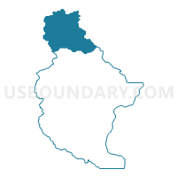
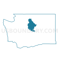
Voting District 190, Chelan County, Washington
About
Outline

Summary
| Unique Area Identifier | 683654 |
| Name | Voting District 190 |
| County | Chelan County |
| State | Washington |
| Area (square miles) | 438.63 |
| Land Area (square miles) | 429.89 |
| Water Area (square miles) | 8.74 |
| % of Land Area | 98.01 |
| % of Water Area | 1.99 |
| Latitude of the Internal Point | 48.35996590 |
| Longtitude of the Internal Point | -120.78591050 |
Maps

Graphs
Select a template below for downloading or customizing gragh for Voting District 190, Chelan County, Washington


Neighbors
Neighoring Voting District (by Name) Neighboring Voting District on the Map
- Voting District 173, Chelan County, WA
- Voting District 182, Chelan County, WA
- Libby Creek Voting District, Okanogan County, WA
- Mazama Voting District, Okanogan County, WA
- Poorman Creek Voting District, Okanogan County, WA
- Sauk Voting District, Snohomish County, WA
- Skagit County, Skagit County, WA
Top 10 Neighboring County Subdivision (by Population) Neighboring County Subdivision on the Map
- Methow Valley CCD, Okanogan County, WA (5,522)
- East Skagit CCD, Skagit County, WA (4,715)
- Darrington CCD, Snohomish County, WA (3,065)
- Early Winters CCD, Okanogan County, WA (368)
- Stehekin CCD, Chelan County, WA (152)
Top 10 Neighboring Unified School District (by Population) Neighboring Unified School District on the Map
- Lake Chelan School District, WA (7,135)
- Methow Valley School District, WA (5,230)
- Concrete School District, WA (4,840)
- Manson School District, WA (3,583)
- Darrington School District, WA (3,210)
- Stehekin School District, WA (104)
Top 10 Neighboring State Legislative District Lower Chamber (by Population) Neighboring State Legislative District Lower Chamber on the Map
Top 10 Neighboring State Legislative District Upper Chamber (by Population) Neighboring State Legislative District Upper Chamber on the Map
Top 10 Neighboring 111th Congressional District (by Population) Neighboring 111th Congressional District on the Map
- Congressional District 4, WA (774,409)
- Congressional District 2, WA (760,041)
- Congressional District 5, WA (723,609)
Top 10 Neighboring Census Tract (by Population) Neighboring Census Tract on the Map
- Census Tract 9511, Skagit County, WA (4,715)
- Census Tract 9710, Okanogan County, WA (3,670)
- Census Tract 537, Snohomish County, WA (3,065)
- Census Tract 9601, Chelan County, WA (2,369)
- Census Tract 9709, Okanogan County, WA (2,220)
Top 10 Neighboring 5-Digit ZIP Code Tabulation Area (by Population) Neighboring 5-Digit ZIP Code Tabulation Area on the Map
- 98816, WA (6,394)
- 98856, WA (2,464)
- 98862, WA (2,218)
- 98241, WA (2,129)
- 98267, WA (534)
- 98833, WA (150)
- 98852, WA (104)